Downloading data from WorldPop.org
import pandas as pd
from epigraphhub.data.worldpop import WorldPop
from IPython.display import display, Markdown, Image
---------------------------------------------------------------------------
ModuleNotFoundError                       Traceback (most recent call last)
/tmp/ipykernel_351/2306285598.py in <module>
      1 import pandas as pd
----> 2 from epigraphhub.data.worldpop import WorldPop
      3 from IPython.display import display, Markdown, Image

ModuleNotFoundError: No module named 'epigraphhub'
To get started we instantiate a WorldPop object to Consume the API.
WP = WorldPop()
The representation of this object is a markdown table describing the contents of the API.
display(Markdown(f"{WP}"))
| alias | name | title | desc |
|:———————|:—————————-|:———————————-|:—————————————————————————————————————————————————————————————————————————————————————————————————————————————————————————————————————————————————————————————————————————————————————————————————————————————————————————————————————————————————————————————————————————————————————————————————————————————————————————————————————————————————————————————————————————————————————————————————————————————————————————————————————————————————————————————————————————————————————————————————————————————————————————-|
| pop | Population Counts | Population Counts | WorldPop produces different types of gridded population count datasets, depending on the methods used and end application. |
| | | | Please make sure you have read our Mapping Populations overview page before choosing and downloading a dataset. |
| | | |
|
| | | | Bespoke methods used to produce datasets for specific individual countries are available through the WorldPop Open Population Repository (WOPR) link below. |
| | | | These are 100m resolution gridded population estimates using customized methods (”bottom-up” and/or “top-down”) developed for the latest data available from each country. |
| | | | They can also be visualised and explored through the woprVision App. |
| | | |
|
| | | | The remaining datasets in the links below are produced using the “top-down” method, |
| | | | with either the unconstrained or constrained top-down disaggregation method used. |
| | | | Please make sure you read the Top-down estimation modelling overview page to decide on which datasets best meet your needs. |
| | | | Datasets are available to download in Geotiff and ASCII XYZ format at a resolution of 3 and 30 arc-seconds (approximately 100m and 1km at the equator, respectively): |
| | | |
|
| | | | - Unconstrained individual countries 2000-2020 ( 1km resolution ): Consistent 1km resolution population count datasets created using |
| | | | unconstrained top-down methods for all countries of the World for each year 2000-2020. |
| | | |
|
| | | | - Unconstrained individual countries 2000-2020 ( 100m resolution ): Consistent 100m resolution population count datasets created using |
| | | | unconstrained top-down methods for all countries of the World for each year 2000-2020. |
| | | |
|
| | | | - Unconstrained individual countries 2000-2020 UN adjusted ( 100m resolution ): Consistent 100m resolution population count datasets created using |
| | | | unconstrained top-down methods for all countries of the World for each year 2000-2020 and adjusted to match United Nations national population estimates (UN 2019) |
| | | |
|
| | | | -Unconstrained individual countries 2000-2020 UN adjusted ( 1km resolution ): Consistent 1km resolution population count datasets created using |
| | | | unconstrained top-down methods for all countries of the World for each year 2000-2020 and adjusted to match United Nations national population estimates (UN 2019). |
| | | |
|
| | | | -Unconstrained global mosaics 2000-2020 ( 1km resolution ): Mosaiced 1km resolution versions of the “Unconstrained individual countries 2000-2020” datasets. |
| | | |
|
| | | | -Constrained individual countries 2020 ( 100m resolution ): Consistent 100m resolution population count datasets created using |
| | | | constrained top-down methods for all countries of the World for 2020. |
| | | |
|
| | | | -Constrained individual countries 2020 UN adjusted ( 100m resolution ): Consistent 100m resolution population count datasets created using |
| | | | constrained top-down methods for all countries of the World for 2020 and adjusted to match United Nations national |
| | | | population estimates (UN 2019). |
| | | |
|
| | | |
|
| | | | Older datasets produced for specific individual countries and continents, using a set of tailored geospatial inputs and differing “top-down” methods and time periods are still available for download here: Individual countries and Whole Continent. |
| births | Births | Births | The health and survival of women and their new-born babies in low income countries is a key public health priority, but basic and consistent subnational data on the number of live births to support decision making has been lacking. WorldPop integrates small area data on the distribution of women of childbearing age and age-specific fertility rates to map the estimated distributions of births for each 1x1km grid square across all low and middle income countries. Further details on the methods can be found in Tatem et al. and James et al.. |
| pregnancies | Pregnancies | Pregnancies | The health and survival of women and their new-born babies in low income countries is a key public health priority, but basic and consistent subnational data on the number of pregnancies to support decision making has been lacking. WorldPop integrates small area data on the distribution of women of childbearing age, age-specific fertility rates, still births and abortions to map the estimated distributions of pregnancies for each 1x1km grid square across all low and middle income countries. Further details on the methods can be found in Tatem et al and James et al.. |
| urban_change | Urban change | Urban change | East–Southeast Asia is currently one of the fastest urbanizing regions in the world, with countries such as China climbing from 20 to 50% urbanized in just a few decades. However, spatially-and temporally-detailed information on regional-scale changes in urban land or population distribution have not previously been available; previous efforts have been either sample-based, focused on one country, or drawn conclusions from datasets with substantial temporal/spatial mismatch and variability in urban definitions. In collaboration with the World Bank and University of Wisconsin-Madison, WorldPop used consistent methodology, satellite imagery and census data for >1000 agglomerations in the East–Southeast Asian region to map population changes between 2000 and 2010. The data are available here and described in detail in Schneider et al, and this report. |
| age_structures | Age and sex structures | Age and sex structures | WorldPop produces different types of gridded population count datasets, depending on the methods used and end application. |
| | | | Please make sure you have read our Mapping Populations overview page before choosing and downloading a dataset. |
| | | |
|
| | | | |
| | | | A description of the modelling methods used for age and sex structures can be found in |
| | | | |
| | | | Tatem et al and |
| | | | Pezzulo et al. Details of the input population count datasets used can be found here, and age/sex structure proportion datasets here. |
| | | |
|
| | | | Both top-down ‘unconstrained’ and ‘constrained’ versions of the datasets are available, and the differences between the two methods are outlined |
| | | | here. The datasets represent the outputs from a project focused on construction of consistent 100m resolution population count datasets for all countries of the World structured by male/female and 5-year age classes (plus a <1 year class). These efforts necessarily involved some shortcuts for consistency. The unconstrained datasets are available for each year from 2000 to 2020. |
| | | | The constrained datasets are only available for 2020 at present, given the time periods represented by the building footprint and built settlement datasets used in the mapping. |
| dahi | Development Indicators | Development and Health Indicators | Improved understanding of geographical variation and inequity in health status, wealth and access to resources within countries is increasingly being recognized as central to meeting development goals. Development and health indicators assessed at national or subnational scale can often conceal important inequities, with the rural poor often least well represented. WorldPop develops methods for the integration of geolocated cluster sample data from household surveys with geospatial covariates in Bayesian geostatistical modelling frameworks to map key development and health indicators at high spatial resolution. These include indicators relating to poverty, literacy, sanitation, maternal and newborn health, contraceptive use and vaccination coverage, among others. Details of methods used and outputs can be found in Utazi et al 1, Utazi et al 2, Steele et al, Bosco et al, Ruktanonchai et al and Tatem et al. |
| dependency_ratios | Dependency Ratios | Dependency Ratios | The age group composition of populations varies substantially across continents and within countries, and is linked to levels of development, health status and poverty. The subnational variability in the shape of the population pyramid as well as the respective dependency ratio are reflective of the different levels of development of a country and are drivers for a country’s economic prospects and health burdens. WorldPop’s assembly of subnational population pyramid data has here been used to produce continent-wide subnational scale dependency ratio datasets, with full details found in Pezzulo et al. |
| internal_migration_f | Migration Flows | Migration Flows | Human mobility continues to increase in terms of volumes and reach, producing growing global connectivity. Quantifying and modeling human migration can contribute towards a better understanding of the nature of migration and help develop evidence-based interventions for |
| | | | disease control policy, economic development, and resource allocation. WorldPop has worked to pair census microdata from multiple low and middle income countries with migrant stock data and additional |
| | | | geospatial datasets to develop models for internal and international migration flows, |
| | | | including key drivers that reflect the changing social, demographic, economic, and |
| | | | environmental landscapes. These have been applied to map internal and international migration at sub-national level for all low and middle income countries, with the datasets available to download here, and methods described in Sorichetta et al, Garcia et al, Ceausu et al., Modelling sex-disaggregated internal migration flows in low- and middle-income countries (in preparation), and Ceausu et al., Estimating sex-disaggregated interregional migration in the Global South (in preparation). |
| dynamic_mapping | Dynamic Mapping | Dynamic Mapping | Knowing where people are is critical for accurate impact assessments and intervention planning, particularly those focused on population health, food security, climate change, conflicts, and natural disasters. WorldPop has demonstrated how data collected by mobile phone network operators can cost-effectively provide accurate and detailed maps of population distribution over national scales and any time period while guaranteeing phone users’ privacy. Methods are described in Deville et al and zu Erbach-Schoenberg et al, and datasets representing estimated monthly population distributions for France and Portugal are available to download here. |
| global_flight_data | Global Flight Data | Global Flight Data | The expanding global air network provides rapid and wide-reaching connections accelerating both domestic and international travel. To understand human movement patterns on the network and their socioeconomic, environmental and epidemiological implications, information on passenger flow is required. However, comprehensive data on global passenger flow remain difficult and expensive to obtain, prompting researchers and analysts to rely on scheduled flight seat capacity data or simple models of flow. WorldPop has collated openly available monthly statistics of air passengers across countries and years, and developed models of global air passenger flows, with annual flow methods described in Huang et al, seasonal flows described in Mao et al, and the dataset collected and output estimates available to download here. |
| covariates | Covariates | Geospatial covariate data layers | Recent years have seen substantial growth in openly available satellite and other geospatial data layers, which represent a range of metrics relevant to global human population mapping at fine spatial scales. The specifications of such data differ widely and therefore the harmonisation of data layers is a prerequisite to constructing detailed and contemporary spatial datasets which accurately describe population distributions. Such datasets are vital to measure impacts of population growth, monitor change, and plan interventions. To this end WorldPop has produced an open access archive of 3 and 30 arc-second resolution gridded data, which are available to download here and are described further in Lloyd et al 2019 and also Lloyd et al 2017. |
| gbsg | Global Settlement Growth | Global Built-Settlement Growth | Changing populations are often accompanied by changing built-settlement landscapes. Here, small area population data and a limited set of environmental covariates have been combined with machine learning methods and dynamically-limited growth curves to annually interpolate (from 2000 to 2014) and annually project (from 2015 to 2020) the presence of built-settlements across the globe at 100m resolution. These annual built-settlement maps were then used to inform the WorldPop “Global per country 2000-2020” population datasets. An overview of the built-settlement growth modeling framework can be found in Nieves et al. |
| gridcellsurfaceareas | Grid-cell surface areas | Grid-cell surface areas | Grid-cell surface areas |
| adminareas | Administrative Areas | Administrative Areas | Administrative Areas |
| pop_density | Population Density | Population Density | WorldPop produces different types of gridded population count datasets, depending on the methods used and end application. |
| | | | Please make sure you have read our Mapping Populations overview page before choosing and downloading a dataset. |
| | | |
|
| | | | Datasets are available to download in Geotiff and ASCII XYZ format at a resolution of 30 arc-seconds (approximately 1km at the equator) |
| | | |
|
| | | | |
| | | | -Unconstrained individual countries 2000-2020: Population density datasets for all countries of the World for each year 2000-2020 – derived from the corresponding |
| | | | Unconstrained individual countries 2000-2020 population count datasets by dividing the number of people in each pixel by the pixel surface area. |
| | | | These are produced using the unconstrained top-down modelling method. |
| | | |
|
| | | | -Unconstrained individual countries 2000-2020 UN adjusted: Population density datasets for all countries of the World for each year 2000-2020 – derived from the corresponding |
| | | | Unconstrained individual countries 2000-2020 population UN adjusted count datasets by dividing the number of people in each pixel, |
| | | | adjusted to match the country total from the official United Nations population estimates (UN 2019), by the pixel surface area. |
| | | | These are produced using the unconstrained top-down modelling method. |
| pwd | Population Weighted Density | Population Weighted Density | Population Weighted Density (PWD) is an alternative to conventional approaches to population density that is arguably better suited to some types of research in the fields of social science and epidemiology. In this release WorldPop publishes what we believe may be the first set of global estimates for PWD, which we offer at national and subnational levels since 2000. |
| | | | Please make sure you have read our Population Weighted Density overview page before choosing and downloading a dataset. |
Downloading table lists
Once we know which dataset we want to explore, for example, population(pop), we can list all the tables available within it by organizational level:
for df in WP.get_dataset_tables("pop"):
    display(Markdown(f"### {df['name']}: *{df['alias']}*"))
    display(df['data'])
Individual countries: pic
| id | title | popyear | iso3 | |
|---|---|---|---|---|
| 0 | 1 | Armenia 100m Population | None | ARM |
| 1 | 2 | Azerbaijan 100m Population | None | AZE |
| 2 | 3 | Iraq 100m Population | None | IRQ |
| 3 | 4 | Saudi Arabia 100m Population | None | SAU |
| 4 | 5 | Uzbekistan 100m Population | None | UZB |
| ... | ... | ... | ... | ... |
| 134 | 135 | Bhutan 100m Population | None | BTN |
| 135 | 136 | State of Palestine 100m Population | None | PSE |
| 136 | 137 | Ukraine 100m Population | None | UKR |
| 137 | 138 | Kazakhstan 100m Population | None | KAZ |
| 138 | 17044 | Nigeria 100m Population | None | NGA |
139 rows × 4 columns
Whole Continent: pop_continent
| id | title | popyear | iso3 | |
|---|---|---|---|---|
| 0 | 139 | Africa Continental Population Datasets (2000 -... | None | WCT |
| 1 | 140 | Asia Continental Population Datasets (2000 - 2... | None | WCA |
| 2 | 141 | Latin America and the Caribbean Continental Po... | None | WCB |
Unconstrained individual countries 2000-2020 ( 100m resolution ): wpgp
| id | title | popyear | iso3 | |
|---|---|---|---|---|
| 0 | 1325 | The spatial distribution of population in 2000... | 2000 | AUS |
| 1 | 1326 | The spatial distribution of population in 2000... | 2000 | RUS |
| 2 | 1327 | The spatial distribution of population in 2000... | 2000 | BRA |
| 3 | 1328 | The spatial distribution of population in 2000... | 2000 | CAN |
| 4 | 1329 | The spatial distribution of population in 2000... | 2000 | CZE |
| ... | ... | ... | ... | ... |
| 5216 | 6541 | The spatial distribution of population in 2020... | 2020 | ATF |
| 5217 | 6542 | The spatial distribution of population in 2020... | 2020 | HMD |
| 5218 | 6543 | The spatial distribution of population in 2020... | 2020 | UMI |
| 5219 | 6544 | The spatial distribution of population in 2020... | 2020 | SPR |
| 5220 | 6545 | The spatial distribution of population in 2020... | 2020 | USA |
5221 rows × 4 columns
Unconstrained global mosaics 2000-2020 ( 1km resolution ): wpgp1km
| id | title | popyear | iso3 | |
|---|---|---|---|---|
| 0 | 24757 | The spatial distribution of population in 2000 | 2000 | None |
| 1 | 24758 | The spatial distribution of population in 2001 | 2001 | None |
| 2 | 24759 | The spatial distribution of population in 2002 | 2002 | None |
| 3 | 24760 | The spatial distribution of population in 2003 | 2003 | None |
| 4 | 24761 | The spatial distribution of population in 2004 | 2004 | None |
| 5 | 24762 | The spatial distribution of population in 2005 | 2005 | None |
| 6 | 24763 | The spatial distribution of population in 2006 | 2006 | None |
| 7 | 24764 | The spatial distribution of population in 2007 | 2007 | None |
| 8 | 24765 | The spatial distribution of population in 2008 | 2008 | None |
| 9 | 24766 | The spatial distribution of population in 2009 | 2009 | None |
| 10 | 24767 | The spatial distribution of population in 2010 | 2010 | None |
| 11 | 24768 | The spatial distribution of population in 2011 | 2011 | None |
| 12 | 24769 | The spatial distribution of population in 2012 | 2012 | None |
| 13 | 24770 | The spatial distribution of population in 2013 | 2013 | None |
| 14 | 24771 | The spatial distribution of population in 2014 | 2014 | None |
| 15 | 24772 | The spatial distribution of population in 2015 | 2015 | None |
| 16 | 24773 | The spatial distribution of population in 2016 | 2016 | None |
| 17 | 24774 | The spatial distribution of population in 2017 | 2017 | None |
| 18 | 24775 | The spatial distribution of population in 2018 | 2018 | None |
| 19 | 24776 | The spatial distribution of population in 2019 | 2019 | None |
| 20 | 24777 | The spatial distribution of population in 2020 | 2020 | None |
WP00643: **
| alias | name | |
|---|---|---|
| 0 | pic | Individual countries |
| 1 | pop_continent | Whole Continent |
| 2 | wpgp | Unconstrained individual countries 2000-2020 (... |
| 3 | wpgp1km | Unconstrained global mosaics 2000-2020 ( 1km r... |
| 4 | WP00643 | |
| 5 | wpgpunadj | Unconstrained individual countries 2000-2020 U... |
| 6 | wpic1km | Unconstrained individual countries 2000-2020 ... |
| 7 | wpicuadj1km | Unconstrained individual countries 2000-2020 U... |
| 8 | cic2020_100m | Constrained Individual countries 2020 ( 100m r... |
| 9 | cic2020_UNadj_100m | Constrained Individual countries 2020 UN adjus... |
Unconstrained individual countries 2000-2020 UN adjusted ( 100m resolution ): wpgpunadj
| id | title | popyear | iso3 | |
|---|---|---|---|---|
| 0 | 24801 | The spatial distribution of population in 2000... | 2000 | RUS |
| 1 | 24802 | The spatial distribution of population in 2001... | 2001 | RUS |
| 2 | 24803 | The spatial distribution of population in 2002... | 2002 | RUS |
| 3 | 24804 | The spatial distribution of population in 2003... | 2003 | RUS |
| 4 | 24805 | The spatial distribution of population in 2004... | 2004 | RUS |
| ... | ... | ... | ... | ... |
| 4885 | 29686 | The spatial distribution of population in 2016... | 2016 | ZMB |
| 4886 | 29687 | The spatial distribution of population in 2017... | 2017 | ZMB |
| 4887 | 29688 | The spatial distribution of population in 2018... | 2018 | ZMB |
| 4888 | 29689 | The spatial distribution of population in 2019... | 2019 | ZMB |
| 4889 | 29690 | The spatial distribution of population in 2020... | 2020 | ZMB |
4890 rows × 4 columns
Unconstrained individual countries 2000-2020 ( 1km resolution ): wpic1km
| id | title | popyear | iso3 | |
|---|---|---|---|---|
| 0 | 29693 | The spatial distribution of population in 2000... | 2000 | RUS |
| 1 | 29694 | The spatial distribution of population in 2001... | 2001 | RUS |
| 2 | 29695 | The spatial distribution of population in 2002... | 2002 | RUS |
| 3 | 29696 | The spatial distribution of population in 2003... | 2003 | RUS |
| 4 | 29697 | The spatial distribution of population in 2004... | 2004 | RUS |
| ... | ... | ... | ... | ... |
| 5056 | 34749 | The spatial distribution of population in 2016... | 2016 | KOS |
| 5057 | 34750 | The spatial distribution of population in 2017... | 2017 | KOS |
| 5058 | 34751 | The spatial distribution of population in 2018... | 2018 | KOS |
| 5059 | 34752 | The spatial distribution of population in 2019... | 2019 | KOS |
| 5060 | 34753 | The spatial distribution of population in 2020... | 2020 | KOS |
5061 rows × 4 columns
Unconstrained individual countries 2000-2020 UN adjusted ( 1km resolution ): wpicuadj1km
| id | title | popyear | iso3 | |
|---|---|---|---|---|
| 0 | 34754 | The spatial distribution of population in 2000... | 2000 | RUS |
| 1 | 34755 | The spatial distribution of population in 2001... | 2001 | RUS |
| 2 | 34756 | The spatial distribution of population in 2002... | 2002 | RUS |
| 3 | 34757 | The spatial distribution of population in 2003... | 2003 | RUS |
| 4 | 34758 | The spatial distribution of population in 2004... | 2004 | RUS |
| ... | ... | ... | ... | ... |
| 4909 | 39663 | The spatial distribution of population in 2016... | 2016 | ZMB |
| 4910 | 39664 | The spatial distribution of population in 2017... | 2017 | ZMB |
| 4911 | 39665 | The spatial distribution of population in 2018... | 2018 | ZMB |
| 4912 | 39666 | The spatial distribution of population in 2019... | 2019 | ZMB |
| 4913 | 39667 | The spatial distribution of population in 2020... | 2020 | ZMB |
4914 rows × 4 columns
Constrained Individual countries 2020 ( 100m resolution ): cic2020_100m
| id | title | popyear | iso3 | |
|---|---|---|---|---|
| 0 | 49623 | The spatial distribution of population in 2020... | 2020 | AGO |
| 1 | 49624 | The spatial distribution of population in 2020... | 2020 | BWA |
| 2 | 49625 | The spatial distribution of population in 2020... | 2020 | BDI |
| 3 | 49626 | The spatial distribution of population in 2020... | 2020 | CMR |
| 4 | 49627 | The spatial distribution of population in 2020... | 2020 | CPV |
| ... | ... | ... | ... | ... |
| 235 | 49909 | The spatial distribution of population in 2020... | 2020 | VEN |
| 236 | 49910 | The spatial distribution of population in 2020... | 2020 | WLF |
| 237 | 49911 | The spatial distribution of population in 2020... | 2020 | WSM |
| 238 | 49912 | The spatial distribution of population in 2020... | 2020 | YEM |
| 239 | 49913 | The spatial distribution of population in 2020... | 2020 | KOS |
240 rows × 4 columns
Constrained Individual countries 2020 UN adjusted (100m resolution): cic2020_UNadj_100m
| id | title | popyear | iso3 | |
|---|---|---|---|---|
| 0 | 49674 | The spatial distribution of population in 2020... | 2020 | AGO |
| 1 | 49675 | The spatial distribution of population in 2020... | 2020 | BWA |
| 2 | 49676 | The spatial distribution of population in 2020... | 2020 | BDI |
| 3 | 49677 | The spatial distribution of population in 2020... | 2020 | CMR |
| 4 | 49678 | The spatial distribution of population in 2020... | 2020 | CPV |
| ... | ... | ... | ... | ... |
| 229 | 50092 | The spatial distribution of population in 2020... | 2020 | UZB |
| 230 | 50093 | The spatial distribution of population in 2020... | 2020 | VEN |
| 231 | 50094 | The spatial distribution of population in 2020... | 2020 | WLF |
| 232 | 50095 | The spatial distribution of population in 2020... | 2020 | WSM |
| 233 | 50096 | The spatial distribution of population in 2020... | 2020 | YEM |
234 rows × 4 columns
The get_dataset_tables is a generator function that returns dictionaries containing on dataframe and metadata at a time.
We can dig deeper to get closer to the actual data: we pick an area, say population (pop), a level, say Unconstrained individual countries 2000-2020 ( 1km resolution ): “wpic1km” and the country: Guyana. This is possible through get_data_by_country.
data = WP.get_data_by_country(alias='pop', level='wpic1km', ISO3_code='GUY')
data
{'data': [{'id': '31604',
   'title': 'The spatial distribution of population in 2000 Guyana',
   'desc': 'Estimated total number of people per grid-cell. The dataset is available to download in Geotiff and ASCII XYZ format at a resolution of 30 arc (approximately 1km at the equator). The projection is Geographic Coordinate System, WGS84. The units are number of people per pixel. The mapping approach is Random Forest-based dasymetric redistribution.',
   'doi': '10.5258/SOTON/WP00670',
   'date': '2020-06-22',
   'popyear': '2000',
   'citation': 'WorldPop (www.worldpop.org - School of Geography and Environmental Science, University of Southampton; Department of Geography and Geosciences, University of Louisville; Departement de Geographie, Universite de Namur) and Center for International Earth Science Information Network (CIESIN), Columbia University (2018). Global High Resolution Population Denominators Project - Funded by The Bill and Melinda Gates Foundation (OPP1134076). https://dx.doi.org/10.5258/SOTON/WP00670',
   'data_file': 'GIS/Population/Global_2000_2020_1km/2000/GUY',
   'archive': 'N',
   'public': 'Y',
   'source': 'WorldPop, University of Southampton, UK',
   'data_format': 'Geotiff',
   'author_email': 'info@worldpop.org',
   'author_name': 'WorldPop',
   'maintainer_name': 'WorldPop',
   'maintainer_email': 'info@worldpop.org',
   'project': 'Population Counts',
   'category': 'Unconstrained individual countries 2000-2020  ( 1km resolution )',
   'gtype': 'Population',
   'continent': 'Americas',
   'country': 'Guyana',
   'iso3': 'GUY',
   'files': ['https://data.worldpop.org/GIS/Population/Global_2000_2020_1km/2000/GUY/guy_ppp_2000_1km_Aggregated.tif',
    'https://data.worldpop.org/GIS/Population/Global_2000_2020_1km/2000/GUY/guy_ppp_2000_1km_ASCII_XYZ.zip'],
   'url_img': 'https://hub.worldpop.org/tabs/gdata/img/31604/guy_ppp_1km_2000_Image.png',
   'organisation': 'WorldPop, University of Southampton, UK, hub.worldpop.org',
   'license': 'https://hub.worldpop.org/data/licence.txt',
   'url_summary': 'https://hub.worldpop.org/geodata/summary?id=31604'},
  {'id': '31605',
   'title': 'The spatial distribution of population in 2001 Guyana',
   'desc': 'Estimated total number of people per grid-cell. The dataset is available to download in Geotiff and ASCII XYZ format at a resolution of 30 arc (approximately 1km at the equator). The projection is Geographic Coordinate System, WGS84. The units are number of people per pixel. The mapping approach is Random Forest-based dasymetric redistribution.',
   'doi': '10.5258/SOTON/WP00670',
   'date': '2020-06-22',
   'popyear': '2001',
   'citation': 'WorldPop (www.worldpop.org - School of Geography and Environmental Science, University of Southampton; Department of Geography and Geosciences, University of Louisville; Departement de Geographie, Universite de Namur) and Center for International Earth Science Information Network (CIESIN), Columbia University (2018). Global High Resolution Population Denominators Project - Funded by The Bill and Melinda Gates Foundation (OPP1134076). https://dx.doi.org/10.5258/SOTON/WP00670',
   'data_file': 'GIS/Population/Global_2000_2020_1km/2001/GUY',
   'archive': 'N',
   'public': 'Y',
   'source': 'WorldPop, University of Southampton, UK',
   'data_format': 'Geotiff',
   'author_email': 'info@worldpop.org',
   'author_name': 'WorldPop',
   'maintainer_name': 'WorldPop',
   'maintainer_email': 'info@worldpop.org',
   'project': 'Population Counts',
   'category': 'Unconstrained individual countries 2000-2020  ( 1km resolution )',
   'gtype': 'Population',
   'continent': 'Americas',
   'country': 'Guyana',
   'iso3': 'GUY',
   'files': ['https://data.worldpop.org/GIS/Population/Global_2000_2020_1km/2001/GUY/guy_ppp_2001_1km_Aggregated.tif',
    'https://data.worldpop.org/GIS/Population/Global_2000_2020_1km/2001/GUY/guy_ppp_2001_1km_ASCII_XYZ.zip'],
   'url_img': 'https://hub.worldpop.org/tabs/gdata/img/31605/guy_ppp_1km_2001_Image.png',
   'organisation': 'WorldPop, University of Southampton, UK, hub.worldpop.org',
   'license': 'https://hub.worldpop.org/data/licence.txt',
   'url_summary': 'https://hub.worldpop.org/geodata/summary?id=31605'},
  {'id': '31606',
   'title': 'The spatial distribution of population in 2002 Guyana',
   'desc': 'Estimated total number of people per grid-cell. The dataset is available to download in Geotiff and ASCII XYZ format at a resolution of 30 arc (approximately 1km at the equator). The projection is Geographic Coordinate System, WGS84. The units are number of people per pixel. The mapping approach is Random Forest-based dasymetric redistribution.',
   'doi': '10.5258/SOTON/WP00670',
   'date': '2020-06-22',
   'popyear': '2002',
   'citation': 'WorldPop (www.worldpop.org - School of Geography and Environmental Science, University of Southampton; Department of Geography and Geosciences, University of Louisville; Departement de Geographie, Universite de Namur) and Center for International Earth Science Information Network (CIESIN), Columbia University (2018). Global High Resolution Population Denominators Project - Funded by The Bill and Melinda Gates Foundation (OPP1134076). https://dx.doi.org/10.5258/SOTON/WP00670',
   'data_file': 'GIS/Population/Global_2000_2020_1km/2002/GUY',
   'archive': 'N',
   'public': 'Y',
   'source': 'WorldPop, University of Southampton, UK',
   'data_format': 'Geotiff',
   'author_email': 'info@worldpop.org',
   'author_name': 'WorldPop',
   'maintainer_name': 'WorldPop',
   'maintainer_email': 'info@worldpop.org',
   'project': 'Population Counts',
   'category': 'Unconstrained individual countries 2000-2020  ( 1km resolution )',
   'gtype': 'Population',
   'continent': 'Americas',
   'country': 'Guyana',
   'iso3': 'GUY',
   'files': ['https://data.worldpop.org/GIS/Population/Global_2000_2020_1km/2002/GUY/guy_ppp_2002_1km_Aggregated.tif',
    'https://data.worldpop.org/GIS/Population/Global_2000_2020_1km/2002/GUY/guy_ppp_2002_1km_ASCII_XYZ.zip'],
   'url_img': 'https://hub.worldpop.org/tabs/gdata/img/31606/guy_ppp_1km_2002_Image.png',
   'organisation': 'WorldPop, University of Southampton, UK, hub.worldpop.org',
   'license': 'https://hub.worldpop.org/data/licence.txt',
   'url_summary': 'https://hub.worldpop.org/geodata/summary?id=31606'},
  {'id': '31607',
   'title': 'The spatial distribution of population in 2003 Guyana',
   'desc': 'Estimated total number of people per grid-cell. The dataset is available to download in Geotiff and ASCII XYZ format at a resolution of 30 arc (approximately 1km at the equator). The projection is Geographic Coordinate System, WGS84. The units are number of people per pixel. The mapping approach is Random Forest-based dasymetric redistribution.',
   'doi': '10.5258/SOTON/WP00670',
   'date': '2020-06-22',
   'popyear': '2003',
   'citation': 'WorldPop (www.worldpop.org - School of Geography and Environmental Science, University of Southampton; Department of Geography and Geosciences, University of Louisville; Departement de Geographie, Universite de Namur) and Center for International Earth Science Information Network (CIESIN), Columbia University (2018). Global High Resolution Population Denominators Project - Funded by The Bill and Melinda Gates Foundation (OPP1134076). https://dx.doi.org/10.5258/SOTON/WP00670',
   'data_file': 'GIS/Population/Global_2000_2020_1km/2003/GUY',
   'archive': 'N',
   'public': 'Y',
   'source': 'WorldPop, University of Southampton, UK',
   'data_format': 'Geotiff',
   'author_email': 'info@worldpop.org',
   'author_name': 'WorldPop',
   'maintainer_name': 'WorldPop',
   'maintainer_email': 'info@worldpop.org',
   'project': 'Population Counts',
   'category': 'Unconstrained individual countries 2000-2020  ( 1km resolution )',
   'gtype': 'Population',
   'continent': 'Americas',
   'country': 'Guyana',
   'iso3': 'GUY',
   'files': ['https://data.worldpop.org/GIS/Population/Global_2000_2020_1km/2003/GUY/guy_ppp_2003_1km_Aggregated.tif',
    'https://data.worldpop.org/GIS/Population/Global_2000_2020_1km/2003/GUY/guy_ppp_2003_1km_ASCII_XYZ.zip'],
   'url_img': 'https://hub.worldpop.org/tabs/gdata/img/31607/guy_ppp_1km_2003_Image.png',
   'organisation': 'WorldPop, University of Southampton, UK, hub.worldpop.org',
   'license': 'https://hub.worldpop.org/data/licence.txt',
   'url_summary': 'https://hub.worldpop.org/geodata/summary?id=31607'},
  {'id': '31608',
   'title': 'The spatial distribution of population in 2004 Guyana',
   'desc': 'Estimated total number of people per grid-cell. The dataset is available to download in Geotiff and ASCII XYZ format at a resolution of 30 arc (approximately 1km at the equator). The projection is Geographic Coordinate System, WGS84. The units are number of people per pixel. The mapping approach is Random Forest-based dasymetric redistribution.',
   'doi': '10.5258/SOTON/WP00670',
   'date': '2020-06-22',
   'popyear': '2004',
   'citation': 'WorldPop (www.worldpop.org - School of Geography and Environmental Science, University of Southampton; Department of Geography and Geosciences, University of Louisville; Departement de Geographie, Universite de Namur) and Center for International Earth Science Information Network (CIESIN), Columbia University (2018). Global High Resolution Population Denominators Project - Funded by The Bill and Melinda Gates Foundation (OPP1134076). https://dx.doi.org/10.5258/SOTON/WP00670',
   'data_file': 'GIS/Population/Global_2000_2020_1km/2004/GUY',
   'archive': 'N',
   'public': 'Y',
   'source': 'WorldPop, University of Southampton, UK',
   'data_format': 'Geotiff',
   'author_email': 'info@worldpop.org',
   'author_name': 'WorldPop',
   'maintainer_name': 'WorldPop',
   'maintainer_email': 'info@worldpop.org',
   'project': 'Population Counts',
   'category': 'Unconstrained individual countries 2000-2020  ( 1km resolution )',
   'gtype': 'Population',
   'continent': 'Americas',
   'country': 'Guyana',
   'iso3': 'GUY',
   'files': ['https://data.worldpop.org/GIS/Population/Global_2000_2020_1km/2004/GUY/guy_ppp_2004_1km_Aggregated.tif',
    'https://data.worldpop.org/GIS/Population/Global_2000_2020_1km/2004/GUY/guy_ppp_2004_1km_ASCII_XYZ.zip'],
   'url_img': 'https://hub.worldpop.org/tabs/gdata/img/31608/guy_ppp_1km_2004_Image.png',
   'organisation': 'WorldPop, University of Southampton, UK, hub.worldpop.org',
   'license': 'https://hub.worldpop.org/data/licence.txt',
   'url_summary': 'https://hub.worldpop.org/geodata/summary?id=31608'},
  {'id': '31609',
   'title': 'The spatial distribution of population in 2005 Guyana',
   'desc': 'Estimated total number of people per grid-cell. The dataset is available to download in Geotiff and ASCII XYZ format at a resolution of 30 arc (approximately 1km at the equator). The projection is Geographic Coordinate System, WGS84. The units are number of people per pixel. The mapping approach is Random Forest-based dasymetric redistribution.',
   'doi': '10.5258/SOTON/WP00670',
   'date': '2020-06-22',
   'popyear': '2005',
   'citation': 'WorldPop (www.worldpop.org - School of Geography and Environmental Science, University of Southampton; Department of Geography and Geosciences, University of Louisville; Departement de Geographie, Universite de Namur) and Center for International Earth Science Information Network (CIESIN), Columbia University (2018). Global High Resolution Population Denominators Project - Funded by The Bill and Melinda Gates Foundation (OPP1134076). https://dx.doi.org/10.5258/SOTON/WP00670',
   'data_file': 'GIS/Population/Global_2000_2020_1km/2005/GUY',
   'archive': 'N',
   'public': 'Y',
   'source': 'WorldPop, University of Southampton, UK',
   'data_format': 'Geotiff',
   'author_email': 'info@worldpop.org',
   'author_name': 'WorldPop',
   'maintainer_name': 'WorldPop',
   'maintainer_email': 'info@worldpop.org',
   'project': 'Population Counts',
   'category': 'Unconstrained individual countries 2000-2020  ( 1km resolution )',
   'gtype': 'Population',
   'continent': 'Americas',
   'country': 'Guyana',
   'iso3': 'GUY',
   'files': ['https://data.worldpop.org/GIS/Population/Global_2000_2020_1km/2005/GUY/guy_ppp_2005_1km_Aggregated.tif',
    'https://data.worldpop.org/GIS/Population/Global_2000_2020_1km/2005/GUY/guy_ppp_2005_1km_ASCII_XYZ.zip'],
   'url_img': 'https://hub.worldpop.org/tabs/gdata/img/31609/guy_ppp_1km_2005_Image.png',
   'organisation': 'WorldPop, University of Southampton, UK, hub.worldpop.org',
   'license': 'https://hub.worldpop.org/data/licence.txt',
   'url_summary': 'https://hub.worldpop.org/geodata/summary?id=31609'},
  {'id': '31610',
   'title': 'The spatial distribution of population in 2006 Guyana',
   'desc': 'Estimated total number of people per grid-cell. The dataset is available to download in Geotiff and ASCII XYZ format at a resolution of 30 arc (approximately 1km at the equator). The projection is Geographic Coordinate System, WGS84. The units are number of people per pixel. The mapping approach is Random Forest-based dasymetric redistribution.',
   'doi': '10.5258/SOTON/WP00670',
   'date': '2020-06-22',
   'popyear': '2006',
   'citation': 'WorldPop (www.worldpop.org - School of Geography and Environmental Science, University of Southampton; Department of Geography and Geosciences, University of Louisville; Departement de Geographie, Universite de Namur) and Center for International Earth Science Information Network (CIESIN), Columbia University (2018). Global High Resolution Population Denominators Project - Funded by The Bill and Melinda Gates Foundation (OPP1134076). https://dx.doi.org/10.5258/SOTON/WP00670',
   'data_file': 'GIS/Population/Global_2000_2020_1km/2006/GUY',
   'archive': 'N',
   'public': 'Y',
   'source': 'WorldPop, University of Southampton, UK',
   'data_format': 'Geotiff',
   'author_email': 'info@worldpop.org',
   'author_name': 'WorldPop',
   'maintainer_name': 'WorldPop',
   'maintainer_email': 'info@worldpop.org',
   'project': 'Population Counts',
   'category': 'Unconstrained individual countries 2000-2020  ( 1km resolution )',
   'gtype': 'Population',
   'continent': 'Americas',
   'country': 'Guyana',
   'iso3': 'GUY',
   'files': ['https://data.worldpop.org/GIS/Population/Global_2000_2020_1km/2006/GUY/guy_ppp_2006_1km_Aggregated.tif',
    'https://data.worldpop.org/GIS/Population/Global_2000_2020_1km/2006/GUY/guy_ppp_2006_1km_ASCII_XYZ.zip'],
   'url_img': 'https://hub.worldpop.org/tabs/gdata/img/31610/guy_ppp_1km_2006_Image.png',
   'organisation': 'WorldPop, University of Southampton, UK, hub.worldpop.org',
   'license': 'https://hub.worldpop.org/data/licence.txt',
   'url_summary': 'https://hub.worldpop.org/geodata/summary?id=31610'},
  {'id': '31611',
   'title': 'The spatial distribution of population in 2007 Guyana',
   'desc': 'Estimated total number of people per grid-cell. The dataset is available to download in Geotiff and ASCII XYZ format at a resolution of 30 arc (approximately 1km at the equator). The projection is Geographic Coordinate System, WGS84. The units are number of people per pixel. The mapping approach is Random Forest-based dasymetric redistribution.',
   'doi': '10.5258/SOTON/WP00670',
   'date': '2020-06-22',
   'popyear': '2007',
   'citation': 'WorldPop (www.worldpop.org - School of Geography and Environmental Science, University of Southampton; Department of Geography and Geosciences, University of Louisville; Departement de Geographie, Universite de Namur) and Center for International Earth Science Information Network (CIESIN), Columbia University (2018). Global High Resolution Population Denominators Project - Funded by The Bill and Melinda Gates Foundation (OPP1134076). https://dx.doi.org/10.5258/SOTON/WP00670',
   'data_file': 'GIS/Population/Global_2000_2020_1km/2007/GUY',
   'archive': 'N',
   'public': 'Y',
   'source': 'WorldPop, University of Southampton, UK',
   'data_format': 'Geotiff',
   'author_email': 'info@worldpop.org',
   'author_name': 'WorldPop',
   'maintainer_name': 'WorldPop',
   'maintainer_email': 'info@worldpop.org',
   'project': 'Population Counts',
   'category': 'Unconstrained individual countries 2000-2020  ( 1km resolution )',
   'gtype': 'Population',
   'continent': 'Americas',
   'country': 'Guyana',
   'iso3': 'GUY',
   'files': ['https://data.worldpop.org/GIS/Population/Global_2000_2020_1km/2007/GUY/guy_ppp_2007_1km_ASCII_XYZ.zip',
    'https://data.worldpop.org/GIS/Population/Global_2000_2020_1km/2007/GUY/guy_ppp_2007_1km_Aggregated.tif'],
   'url_img': 'https://hub.worldpop.org/tabs/gdata/img/31611/guy_ppp_1km_2007_Image.png',
   'organisation': 'WorldPop, University of Southampton, UK, hub.worldpop.org',
   'license': 'https://hub.worldpop.org/data/licence.txt',
   'url_summary': 'https://hub.worldpop.org/geodata/summary?id=31611'},
  {'id': '31612',
   'title': 'The spatial distribution of population in 2008 Guyana',
   'desc': 'Estimated total number of people per grid-cell. The dataset is available to download in Geotiff and ASCII XYZ format at a resolution of 30 arc (approximately 1km at the equator). The projection is Geographic Coordinate System, WGS84. The units are number of people per pixel. The mapping approach is Random Forest-based dasymetric redistribution.',
   'doi': '10.5258/SOTON/WP00670',
   'date': '2020-06-22',
   'popyear': '2008',
   'citation': 'WorldPop (www.worldpop.org - School of Geography and Environmental Science, University of Southampton; Department of Geography and Geosciences, University of Louisville; Departement de Geographie, Universite de Namur) and Center for International Earth Science Information Network (CIESIN), Columbia University (2018). Global High Resolution Population Denominators Project - Funded by The Bill and Melinda Gates Foundation (OPP1134076). https://dx.doi.org/10.5258/SOTON/WP00670',
   'data_file': 'GIS/Population/Global_2000_2020_1km/2008/GUY',
   'archive': 'N',
   'public': 'Y',
   'source': 'WorldPop, University of Southampton, UK',
   'data_format': 'Geotiff',
   'author_email': 'info@worldpop.org',
   'author_name': 'WorldPop',
   'maintainer_name': 'WorldPop',
   'maintainer_email': 'info@worldpop.org',
   'project': 'Population Counts',
   'category': 'Unconstrained individual countries 2000-2020  ( 1km resolution )',
   'gtype': 'Population',
   'continent': 'Americas',
   'country': 'Guyana',
   'iso3': 'GUY',
   'files': ['https://data.worldpop.org/GIS/Population/Global_2000_2020_1km/2008/GUY/guy_ppp_2008_1km_Aggregated.tif',
    'https://data.worldpop.org/GIS/Population/Global_2000_2020_1km/2008/GUY/guy_ppp_2008_1km_ASCII_XYZ.zip'],
   'url_img': 'https://hub.worldpop.org/tabs/gdata/img/31612/guy_ppp_1km_2008_Image.png',
   'organisation': 'WorldPop, University of Southampton, UK, hub.worldpop.org',
   'license': 'https://hub.worldpop.org/data/licence.txt',
   'url_summary': 'https://hub.worldpop.org/geodata/summary?id=31612'},
  {'id': '31613',
   'title': 'The spatial distribution of population in 2009 Guyana',
   'desc': 'Estimated total number of people per grid-cell. The dataset is available to download in Geotiff and ASCII XYZ format at a resolution of 30 arc (approximately 1km at the equator). The projection is Geographic Coordinate System, WGS84. The units are number of people per pixel. The mapping approach is Random Forest-based dasymetric redistribution.',
   'doi': '10.5258/SOTON/WP00670',
   'date': '2020-06-22',
   'popyear': '2009',
   'citation': 'WorldPop (www.worldpop.org - School of Geography and Environmental Science, University of Southampton; Department of Geography and Geosciences, University of Louisville; Departement de Geographie, Universite de Namur) and Center for International Earth Science Information Network (CIESIN), Columbia University (2018). Global High Resolution Population Denominators Project - Funded by The Bill and Melinda Gates Foundation (OPP1134076). https://dx.doi.org/10.5258/SOTON/WP00670',
   'data_file': 'GIS/Population/Global_2000_2020_1km/2009/GUY',
   'archive': 'N',
   'public': 'Y',
   'source': 'WorldPop, University of Southampton, UK',
   'data_format': 'Geotiff',
   'author_email': 'info@worldpop.org',
   'author_name': 'WorldPop',
   'maintainer_name': 'WorldPop',
   'maintainer_email': 'info@worldpop.org',
   'project': 'Population Counts',
   'category': 'Unconstrained individual countries 2000-2020  ( 1km resolution )',
   'gtype': 'Population',
   'continent': 'Americas',
   'country': 'Guyana',
   'iso3': 'GUY',
   'files': ['https://data.worldpop.org/GIS/Population/Global_2000_2020_1km/2009/GUY/guy_ppp_2009_1km_ASCII_XYZ.zip',
    'https://data.worldpop.org/GIS/Population/Global_2000_2020_1km/2009/GUY/guy_ppp_2009_1km_Aggregated.tif'],
   'url_img': 'https://hub.worldpop.org/tabs/gdata/img/31613/guy_ppp_1km_2009_Image.png',
   'organisation': 'WorldPop, University of Southampton, UK, hub.worldpop.org',
   'license': 'https://hub.worldpop.org/data/licence.txt',
   'url_summary': 'https://hub.worldpop.org/geodata/summary?id=31613'},
  {'id': '31614',
   'title': 'The spatial distribution of population in 2010 Guyana',
   'desc': 'Estimated total number of people per grid-cell. The dataset is available to download in Geotiff and ASCII XYZ format at a resolution of 30 arc (approximately 1km at the equator). The projection is Geographic Coordinate System, WGS84. The units are number of people per pixel. The mapping approach is Random Forest-based dasymetric redistribution.',
   'doi': '10.5258/SOTON/WP00670',
   'date': '2020-06-22',
   'popyear': '2010',
   'citation': 'WorldPop (www.worldpop.org - School of Geography and Environmental Science, University of Southampton; Department of Geography and Geosciences, University of Louisville; Departement de Geographie, Universite de Namur) and Center for International Earth Science Information Network (CIESIN), Columbia University (2018). Global High Resolution Population Denominators Project - Funded by The Bill and Melinda Gates Foundation (OPP1134076). https://dx.doi.org/10.5258/SOTON/WP00670',
   'data_file': 'GIS/Population/Global_2000_2020_1km/2010/GUY',
   'archive': 'N',
   'public': 'Y',
   'source': 'WorldPop, University of Southampton, UK',
   'data_format': 'Geotiff',
   'author_email': 'info@worldpop.org',
   'author_name': 'WorldPop',
   'maintainer_name': 'WorldPop',
   'maintainer_email': 'info@worldpop.org',
   'project': 'Population Counts',
   'category': 'Unconstrained individual countries 2000-2020  ( 1km resolution )',
   'gtype': 'Population',
   'continent': 'Americas',
   'country': 'Guyana',
   'iso3': 'GUY',
   'files': ['https://data.worldpop.org/GIS/Population/Global_2000_2020_1km/2010/GUY/guy_ppp_2010_1km_ASCII_XYZ.zip',
    'https://data.worldpop.org/GIS/Population/Global_2000_2020_1km/2010/GUY/guy_ppp_2010_1km_Aggregated.tif'],
   'url_img': 'https://hub.worldpop.org/tabs/gdata/img/31614/guy_ppp_1km_2010_Image.png',
   'organisation': 'WorldPop, University of Southampton, UK, hub.worldpop.org',
   'license': 'https://hub.worldpop.org/data/licence.txt',
   'url_summary': 'https://hub.worldpop.org/geodata/summary?id=31614'},
  {'id': '31615',
   'title': 'The spatial distribution of population in 2011 Guyana',
   'desc': 'Estimated total number of people per grid-cell. The dataset is available to download in Geotiff and ASCII XYZ format at a resolution of 30 arc (approximately 1km at the equator). The projection is Geographic Coordinate System, WGS84. The units are number of people per pixel. The mapping approach is Random Forest-based dasymetric redistribution.',
   'doi': '10.5258/SOTON/WP00670',
   'date': '2020-06-22',
   'popyear': '2011',
   'citation': 'WorldPop (www.worldpop.org - School of Geography and Environmental Science, University of Southampton; Department of Geography and Geosciences, University of Louisville; Departement de Geographie, Universite de Namur) and Center for International Earth Science Information Network (CIESIN), Columbia University (2018). Global High Resolution Population Denominators Project - Funded by The Bill and Melinda Gates Foundation (OPP1134076). https://dx.doi.org/10.5258/SOTON/WP00670',
   'data_file': 'GIS/Population/Global_2000_2020_1km/2011/GUY',
   'archive': 'N',
   'public': 'Y',
   'source': 'WorldPop, University of Southampton, UK',
   'data_format': 'Geotiff',
   'author_email': 'info@worldpop.org',
   'author_name': 'WorldPop',
   'maintainer_name': 'WorldPop',
   'maintainer_email': 'info@worldpop.org',
   'project': 'Population Counts',
   'category': 'Unconstrained individual countries 2000-2020  ( 1km resolution )',
   'gtype': 'Population',
   'continent': 'Americas',
   'country': 'Guyana',
   'iso3': 'GUY',
   'files': ['https://data.worldpop.org/GIS/Population/Global_2000_2020_1km/2011/GUY/guy_ppp_2011_1km_Aggregated.tif',
    'https://data.worldpop.org/GIS/Population/Global_2000_2020_1km/2011/GUY/guy_ppp_2011_1km_ASCII_XYZ.zip'],
   'url_img': 'https://hub.worldpop.org/tabs/gdata/img/31615/guy_ppp_1km_2011_Image.png',
   'organisation': 'WorldPop, University of Southampton, UK, hub.worldpop.org',
   'license': 'https://hub.worldpop.org/data/licence.txt',
   'url_summary': 'https://hub.worldpop.org/geodata/summary?id=31615'},
  {'id': '31616',
   'title': 'The spatial distribution of population in 2012 Guyana',
   'desc': 'Estimated total number of people per grid-cell. The dataset is available to download in Geotiff and ASCII XYZ format at a resolution of 30 arc (approximately 1km at the equator). The projection is Geographic Coordinate System, WGS84. The units are number of people per pixel. The mapping approach is Random Forest-based dasymetric redistribution.',
   'doi': '10.5258/SOTON/WP00670',
   'date': '2020-06-22',
   'popyear': '2012',
   'citation': 'WorldPop (www.worldpop.org - School of Geography and Environmental Science, University of Southampton; Department of Geography and Geosciences, University of Louisville; Departement de Geographie, Universite de Namur) and Center for International Earth Science Information Network (CIESIN), Columbia University (2018). Global High Resolution Population Denominators Project - Funded by The Bill and Melinda Gates Foundation (OPP1134076). https://dx.doi.org/10.5258/SOTON/WP00670',
   'data_file': 'GIS/Population/Global_2000_2020_1km/2012/GUY',
   'archive': 'N',
   'public': 'Y',
   'source': 'WorldPop, University of Southampton, UK',
   'data_format': 'Geotiff',
   'author_email': 'info@worldpop.org',
   'author_name': 'WorldPop',
   'maintainer_name': 'WorldPop',
   'maintainer_email': 'info@worldpop.org',
   'project': 'Population Counts',
   'category': 'Unconstrained individual countries 2000-2020  ( 1km resolution )',
   'gtype': 'Population',
   'continent': 'Americas',
   'country': 'Guyana',
   'iso3': 'GUY',
   'files': ['https://data.worldpop.org/GIS/Population/Global_2000_2020_1km/2012/GUY/guy_ppp_2012_1km_ASCII_XYZ.zip',
    'https://data.worldpop.org/GIS/Population/Global_2000_2020_1km/2012/GUY/guy_ppp_2012_1km_Aggregated.tif'],
   'url_img': 'https://hub.worldpop.org/tabs/gdata/img/31616/guy_ppp_1km_2012_Image.png',
   'organisation': 'WorldPop, University of Southampton, UK, hub.worldpop.org',
   'license': 'https://hub.worldpop.org/data/licence.txt',
   'url_summary': 'https://hub.worldpop.org/geodata/summary?id=31616'},
  {'id': '31617',
   'title': 'The spatial distribution of population in 2013 Guyana',
   'desc': 'Estimated total number of people per grid-cell. The dataset is available to download in Geotiff and ASCII XYZ format at a resolution of 30 arc (approximately 1km at the equator). The projection is Geographic Coordinate System, WGS84. The units are number of people per pixel. The mapping approach is Random Forest-based dasymetric redistribution.',
   'doi': '10.5258/SOTON/WP00670',
   'date': '2020-06-22',
   'popyear': '2013',
   'citation': 'WorldPop (www.worldpop.org - School of Geography and Environmental Science, University of Southampton; Department of Geography and Geosciences, University of Louisville; Departement de Geographie, Universite de Namur) and Center for International Earth Science Information Network (CIESIN), Columbia University (2018). Global High Resolution Population Denominators Project - Funded by The Bill and Melinda Gates Foundation (OPP1134076). https://dx.doi.org/10.5258/SOTON/WP00670',
   'data_file': 'GIS/Population/Global_2000_2020_1km/2013/GUY',
   'archive': 'N',
   'public': 'Y',
   'source': 'WorldPop, University of Southampton, UK',
   'data_format': 'Geotiff',
   'author_email': 'info@worldpop.org',
   'author_name': 'WorldPop',
   'maintainer_name': 'WorldPop',
   'maintainer_email': 'info@worldpop.org',
   'project': 'Population Counts',
   'category': 'Unconstrained individual countries 2000-2020  ( 1km resolution )',
   'gtype': 'Population',
   'continent': 'Americas',
   'country': 'Guyana',
   'iso3': 'GUY',
   'files': ['https://data.worldpop.org/GIS/Population/Global_2000_2020_1km/2013/GUY/guy_ppp_2013_1km_ASCII_XYZ.zip',
    'https://data.worldpop.org/GIS/Population/Global_2000_2020_1km/2013/GUY/guy_ppp_2013_1km_Aggregated.tif'],
   'url_img': 'https://hub.worldpop.org/tabs/gdata/img/31617/guy_ppp_1km_2013_Image.png',
   'organisation': 'WorldPop, University of Southampton, UK, hub.worldpop.org',
   'license': 'https://hub.worldpop.org/data/licence.txt',
   'url_summary': 'https://hub.worldpop.org/geodata/summary?id=31617'},
  {'id': '31618',
   'title': 'The spatial distribution of population in 2014 Guyana',
   'desc': 'Estimated total number of people per grid-cell. The dataset is available to download in Geotiff and ASCII XYZ format at a resolution of 30 arc (approximately 1km at the equator). The projection is Geographic Coordinate System, WGS84. The units are number of people per pixel. The mapping approach is Random Forest-based dasymetric redistribution.',
   'doi': '10.5258/SOTON/WP00670',
   'date': '2020-06-22',
   'popyear': '2014',
   'citation': 'WorldPop (www.worldpop.org - School of Geography and Environmental Science, University of Southampton; Department of Geography and Geosciences, University of Louisville; Departement de Geographie, Universite de Namur) and Center for International Earth Science Information Network (CIESIN), Columbia University (2018). Global High Resolution Population Denominators Project - Funded by The Bill and Melinda Gates Foundation (OPP1134076). https://dx.doi.org/10.5258/SOTON/WP00670',
   'data_file': 'GIS/Population/Global_2000_2020_1km/2014/GUY',
   'archive': 'N',
   'public': 'Y',
   'source': 'WorldPop, University of Southampton, UK',
   'data_format': 'Geotiff',
   'author_email': 'info@worldpop.org',
   'author_name': 'WorldPop',
   'maintainer_name': 'WorldPop',
   'maintainer_email': 'info@worldpop.org',
   'project': 'Population Counts',
   'category': 'Unconstrained individual countries 2000-2020  ( 1km resolution )',
   'gtype': 'Population',
   'continent': 'Americas',
   'country': 'Guyana',
   'iso3': 'GUY',
   'files': ['https://data.worldpop.org/GIS/Population/Global_2000_2020_1km/2014/GUY/guy_ppp_2014_1km_ASCII_XYZ.zip',
    'https://data.worldpop.org/GIS/Population/Global_2000_2020_1km/2014/GUY/guy_ppp_2014_1km_Aggregated.tif'],
   'url_img': 'https://hub.worldpop.org/tabs/gdata/img/31618/guy_ppp_1km_2014_Image.png',
   'organisation': 'WorldPop, University of Southampton, UK, hub.worldpop.org',
   'license': 'https://hub.worldpop.org/data/licence.txt',
   'url_summary': 'https://hub.worldpop.org/geodata/summary?id=31618'},
  {'id': '31619',
   'title': 'The spatial distribution of population in 2015 Guyana',
   'desc': 'Estimated total number of people per grid-cell. The dataset is available to download in Geotiff and ASCII XYZ format at a resolution of 30 arc (approximately 1km at the equator). The projection is Geographic Coordinate System, WGS84. The units are number of people per pixel. The mapping approach is Random Forest-based dasymetric redistribution.',
   'doi': '10.5258/SOTON/WP00670',
   'date': '2020-06-22',
   'popyear': '2015',
   'citation': 'WorldPop (www.worldpop.org - School of Geography and Environmental Science, University of Southampton; Department of Geography and Geosciences, University of Louisville; Departement de Geographie, Universite de Namur) and Center for International Earth Science Information Network (CIESIN), Columbia University (2018). Global High Resolution Population Denominators Project - Funded by The Bill and Melinda Gates Foundation (OPP1134076). https://dx.doi.org/10.5258/SOTON/WP00670',
   'data_file': 'GIS/Population/Global_2000_2020_1km/2015/GUY',
   'archive': 'N',
   'public': 'Y',
   'source': 'WorldPop, University of Southampton, UK',
   'data_format': 'Geotiff',
   'author_email': 'info@worldpop.org',
   'author_name': 'WorldPop',
   'maintainer_name': 'WorldPop',
   'maintainer_email': 'info@worldpop.org',
   'project': 'Population Counts',
   'category': 'Unconstrained individual countries 2000-2020  ( 1km resolution )',
   'gtype': 'Population',
   'continent': 'Americas',
   'country': 'Guyana',
   'iso3': 'GUY',
   'files': ['https://data.worldpop.org/GIS/Population/Global_2000_2020_1km/2015/GUY/guy_ppp_2015_1km_Aggregated.tif',
    'https://data.worldpop.org/GIS/Population/Global_2000_2020_1km/2015/GUY/guy_ppp_2015_1km_ASCII_XYZ.zip'],
   'url_img': 'https://hub.worldpop.org/tabs/gdata/img/31619/guy_ppp_1km_2015_Image.png',
   'organisation': 'WorldPop, University of Southampton, UK, hub.worldpop.org',
   'license': 'https://hub.worldpop.org/data/licence.txt',
   'url_summary': 'https://hub.worldpop.org/geodata/summary?id=31619'},
  {'id': '31620',
   'title': 'The spatial distribution of population in 2016 Guyana',
   'desc': 'Estimated total number of people per grid-cell. The dataset is available to download in Geotiff and ASCII XYZ format at a resolution of 30 arc (approximately 1km at the equator). The projection is Geographic Coordinate System, WGS84. The units are number of people per pixel. The mapping approach is Random Forest-based dasymetric redistribution.',
   'doi': '10.5258/SOTON/WP00670',
   'date': '2020-06-22',
   'popyear': '2016',
   'citation': 'WorldPop (www.worldpop.org - School of Geography and Environmental Science, University of Southampton; Department of Geography and Geosciences, University of Louisville; Departement de Geographie, Universite de Namur) and Center for International Earth Science Information Network (CIESIN), Columbia University (2018). Global High Resolution Population Denominators Project - Funded by The Bill and Melinda Gates Foundation (OPP1134076). https://dx.doi.org/10.5258/SOTON/WP00670',
   'data_file': 'GIS/Population/Global_2000_2020_1km/2016/GUY',
   'archive': 'N',
   'public': 'Y',
   'source': 'WorldPop, University of Southampton, UK',
   'data_format': 'Geotiff',
   'author_email': 'info@worldpop.org',
   'author_name': 'WorldPop',
   'maintainer_name': 'WorldPop',
   'maintainer_email': 'info@worldpop.org',
   'project': 'Population Counts',
   'category': 'Unconstrained individual countries 2000-2020  ( 1km resolution )',
   'gtype': 'Population',
   'continent': 'Americas',
   'country': 'Guyana',
   'iso3': 'GUY',
   'files': ['https://data.worldpop.org/GIS/Population/Global_2000_2020_1km/2016/GUY/guy_ppp_2016_1km_ASCII_XYZ.zip',
    'https://data.worldpop.org/GIS/Population/Global_2000_2020_1km/2016/GUY/guy_ppp_2016_1km_Aggregated.tif'],
   'url_img': 'https://hub.worldpop.org/tabs/gdata/img/31620/guy_ppp_1km_2016_Image.png',
   'organisation': 'WorldPop, University of Southampton, UK, hub.worldpop.org',
   'license': 'https://hub.worldpop.org/data/licence.txt',
   'url_summary': 'https://hub.worldpop.org/geodata/summary?id=31620'},
  {'id': '31621',
   'title': 'The spatial distribution of population in 2017 Guyana',
   'desc': 'Estimated total number of people per grid-cell. The dataset is available to download in Geotiff and ASCII XYZ format at a resolution of 30 arc (approximately 1km at the equator). The projection is Geographic Coordinate System, WGS84. The units are number of people per pixel. The mapping approach is Random Forest-based dasymetric redistribution.',
   'doi': '10.5258/SOTON/WP00670',
   'date': '2020-06-22',
   'popyear': '2017',
   'citation': 'WorldPop (www.worldpop.org - School of Geography and Environmental Science, University of Southampton; Department of Geography and Geosciences, University of Louisville; Departement de Geographie, Universite de Namur) and Center for International Earth Science Information Network (CIESIN), Columbia University (2018). Global High Resolution Population Denominators Project - Funded by The Bill and Melinda Gates Foundation (OPP1134076). https://dx.doi.org/10.5258/SOTON/WP00670',
   'data_file': 'GIS/Population/Global_2000_2020_1km/2017/GUY',
   'archive': 'N',
   'public': 'Y',
   'source': 'WorldPop, University of Southampton, UK',
   'data_format': 'Geotiff',
   'author_email': 'info@worldpop.org',
   'author_name': 'WorldPop',
   'maintainer_name': 'WorldPop',
   'maintainer_email': 'info@worldpop.org',
   'project': 'Population Counts',
   'category': 'Unconstrained individual countries 2000-2020  ( 1km resolution )',
   'gtype': 'Population',
   'continent': 'Americas',
   'country': 'Guyana',
   'iso3': 'GUY',
   'files': ['https://data.worldpop.org/GIS/Population/Global_2000_2020_1km/2017/GUY/guy_ppp_2017_1km_ASCII_XYZ.zip',
    'https://data.worldpop.org/GIS/Population/Global_2000_2020_1km/2017/GUY/guy_ppp_2017_1km_Aggregated.tif'],
   'url_img': 'https://hub.worldpop.org/tabs/gdata/img/31621/guy_ppp_1km_2017_Image.png',
   'organisation': 'WorldPop, University of Southampton, UK, hub.worldpop.org',
   'license': 'https://hub.worldpop.org/data/licence.txt',
   'url_summary': 'https://hub.worldpop.org/geodata/summary?id=31621'},
  {'id': '31622',
   'title': 'The spatial distribution of population in 2018 Guyana',
   'desc': 'Estimated total number of people per grid-cell. The dataset is available to download in Geotiff and ASCII XYZ format at a resolution of 30 arc (approximately 1km at the equator). The projection is Geographic Coordinate System, WGS84. The units are number of people per pixel. The mapping approach is Random Forest-based dasymetric redistribution.',
   'doi': '10.5258/SOTON/WP00670',
   'date': '2020-06-22',
   'popyear': '2018',
   'citation': 'WorldPop (www.worldpop.org - School of Geography and Environmental Science, University of Southampton; Department of Geography and Geosciences, University of Louisville; Departement de Geographie, Universite de Namur) and Center for International Earth Science Information Network (CIESIN), Columbia University (2018). Global High Resolution Population Denominators Project - Funded by The Bill and Melinda Gates Foundation (OPP1134076). https://dx.doi.org/10.5258/SOTON/WP00670',
   'data_file': 'GIS/Population/Global_2000_2020_1km/2018/GUY',
   'archive': 'N',
   'public': 'Y',
   'source': 'WorldPop, University of Southampton, UK',
   'data_format': 'Geotiff',
   'author_email': 'info@worldpop.org',
   'author_name': 'WorldPop',
   'maintainer_name': 'WorldPop',
   'maintainer_email': 'info@worldpop.org',
   'project': 'Population Counts',
   'category': 'Unconstrained individual countries 2000-2020  ( 1km resolution )',
   'gtype': 'Population',
   'continent': 'Americas',
   'country': 'Guyana',
   'iso3': 'GUY',
   'files': ['https://data.worldpop.org/GIS/Population/Global_2000_2020_1km/2018/GUY/guy_ppp_2018_1km_Aggregated.tif',
    'https://data.worldpop.org/GIS/Population/Global_2000_2020_1km/2018/GUY/guy_ppp_2018_1km_ASCII_XYZ.zip'],
   'url_img': 'https://hub.worldpop.org/tabs/gdata/img/31622/guy_ppp_1km_2018_Image.png',
   'organisation': 'WorldPop, University of Southampton, UK, hub.worldpop.org',
   'license': 'https://hub.worldpop.org/data/licence.txt',
   'url_summary': 'https://hub.worldpop.org/geodata/summary?id=31622'},
  {'id': '31623',
   'title': 'The spatial distribution of population in 2019 Guyana',
   'desc': 'Estimated total number of people per grid-cell. The dataset is available to download in Geotiff and ASCII XYZ format at a resolution of 30 arc (approximately 1km at the equator). The projection is Geographic Coordinate System, WGS84. The units are number of people per pixel. The mapping approach is Random Forest-based dasymetric redistribution.',
   'doi': '10.5258/SOTON/WP00670',
   'date': '2020-06-22',
   'popyear': '2019',
   'citation': 'WorldPop (www.worldpop.org - School of Geography and Environmental Science, University of Southampton; Department of Geography and Geosciences, University of Louisville; Departement de Geographie, Universite de Namur) and Center for International Earth Science Information Network (CIESIN), Columbia University (2018). Global High Resolution Population Denominators Project - Funded by The Bill and Melinda Gates Foundation (OPP1134076). https://dx.doi.org/10.5258/SOTON/WP00670',
   'data_file': 'GIS/Population/Global_2000_2020_1km/2019/GUY',
   'archive': 'N',
   'public': 'Y',
   'source': 'WorldPop, University of Southampton, UK',
   'data_format': 'Geotiff',
   'author_email': 'info@worldpop.org',
   'author_name': 'WorldPop',
   'maintainer_name': 'WorldPop',
   'maintainer_email': 'info@worldpop.org',
   'project': 'Population Counts',
   'category': 'Unconstrained individual countries 2000-2020  ( 1km resolution )',
   'gtype': 'Population',
   'continent': 'Americas',
   'country': 'Guyana',
   'iso3': 'GUY',
   'files': ['https://data.worldpop.org/GIS/Population/Global_2000_2020_1km/2019/GUY/guy_ppp_2019_1km_Aggregated.tif',
    'https://data.worldpop.org/GIS/Population/Global_2000_2020_1km/2019/GUY/guy_ppp_2019_1km_ASCII_XYZ.zip'],
   'url_img': 'https://hub.worldpop.org/tabs/gdata/img/31623/guy_ppp_1km_2019_Image.png',
   'organisation': 'WorldPop, University of Southampton, UK, hub.worldpop.org',
   'license': 'https://hub.worldpop.org/data/licence.txt',
   'url_summary': 'https://hub.worldpop.org/geodata/summary?id=31623'},
  {'id': '31624',
   'title': 'The spatial distribution of population in 2020 Guyana',
   'desc': 'Estimated total number of people per grid-cell. The dataset is available to download in Geotiff and ASCII XYZ format at a resolution of 30 arc (approximately 1km at the equator). The projection is Geographic Coordinate System, WGS84. The units are number of people per pixel. The mapping approach is Random Forest-based dasymetric redistribution.',
   'doi': '10.5258/SOTON/WP00670',
   'date': '2020-06-22',
   'popyear': '2020',
   'citation': 'WorldPop (www.worldpop.org - School of Geography and Environmental Science, University of Southampton; Department of Geography and Geosciences, University of Louisville; Departement de Geographie, Universite de Namur) and Center for International Earth Science Information Network (CIESIN), Columbia University (2018). Global High Resolution Population Denominators Project - Funded by The Bill and Melinda Gates Foundation (OPP1134076). https://dx.doi.org/10.5258/SOTON/WP00670',
   'data_file': 'GIS/Population/Global_2000_2020_1km/2020/GUY',
   'archive': 'N',
   'public': 'Y',
   'source': 'WorldPop, University of Southampton, UK',
   'data_format': 'Geotiff',
   'author_email': 'info@worldpop.org',
   'author_name': 'WorldPop',
   'maintainer_name': 'WorldPop',
   'maintainer_email': 'info@worldpop.org',
   'project': 'Population Counts',
   'category': 'Unconstrained individual countries 2000-2020  ( 1km resolution )',
   'gtype': 'Population',
   'continent': 'Americas',
   'country': 'Guyana',
   'iso3': 'GUY',
   'files': ['https://data.worldpop.org/GIS/Population/Global_2000_2020_1km/2020/GUY/guy_ppp_2020_1km_ASCII_XYZ.zip',
    'https://data.worldpop.org/GIS/Population/Global_2000_2020_1km/2020/GUY/guy_ppp_2020_1km_Aggregated.tif'],
   'url_img': 'https://hub.worldpop.org/tabs/gdata/img/31624/guy_ppp_1km_2020_Image.png',
   'organisation': 'WorldPop, University of Southampton, UK, hub.worldpop.org',
   'license': 'https://hub.worldpop.org/data/licence.txt',
   'url_summary': 'https://hub.worldpop.org/geodata/summary?id=31624'}]}
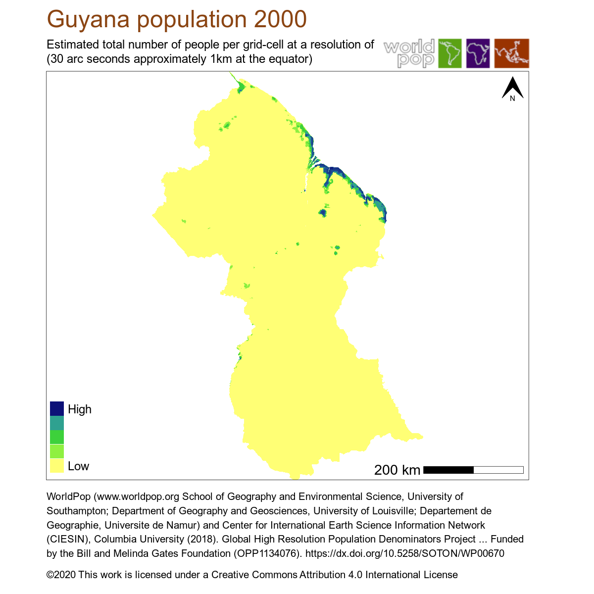
The available file is a geotiff so we need to download it. First we can download a jpg thumbnail of the image we are trying to fetch:
Image(data['data'][0]['url_img'])
import rioxarray as rx
import wget
This geoTiff for Guyana has a resolution of 1 km per pixel
wget.download(data['data'][0]['files'][0], out="guy_pop.tif")
100% [..........................................................................] 1214922 / 1214922
'guy_pop.tif'
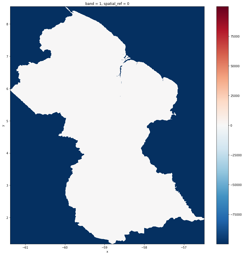
tif = rx.open_rasterio('guy_pop.tif')
tif
<xarray.DataArray (band: 1, y: 883, x: 588)>
[519204 values with dtype=float32]
Coordinates:
  * band         (band) int64 1
  * x            (x) float64 -61.38 -61.37 -61.36 -61.36 ... -56.51 -56.5 -56.49
  * y            (y) float64 8.537 8.529 8.52 8.512 ... 1.212 1.204 1.195 1.187
    spatial_ref  int64 0
Attributes:
    STATISTICS_MAXIMUM:  4141.1645507812
    STATISTICS_MEAN:     3.0038072312959
    STATISTICS_MINIMUM:  0
    STATISTICS_STDDEV:   51.022568488192
    _FillValue:          -99999.0
    scale_factor:        1.0
add_offset: 0.0tif.plot(figsize=(15,15));
tif.plot?